A Survey of Remote Sensing Methods for the Measurement of Anthropogenic Aerosols
Research Presented as a part of my master's study in Applied Physics at Johns Hopkins University
March 9th, 2025
Introduction
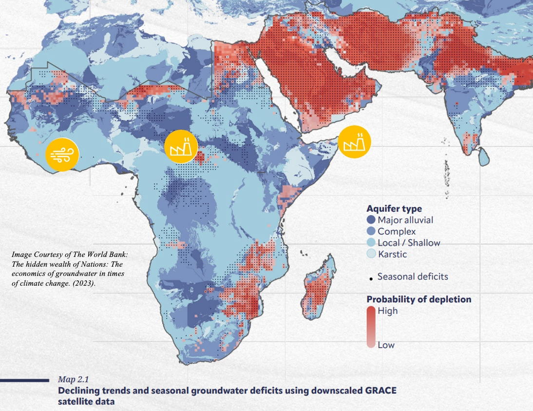
The northern region of India serves as the primary “breadbasket” for over 10% of the world’s population. Here, crops like wheat and rice rely on robust groundwater reserves to sustain over a billion people. These reserves, however, are dropping. Today, The World Bank places northern India at High Risk of groundwater depletion (The World Bank, 2023). This loss has been accelerated in recent years by a consistent decline in monsoon precipitation, with estimates measuring recent monsoon seasons as ~8% drier than those in the 1950’s (Mishra et al., 2024). While multiple causes have been cited, an abundance of research points to anthropogenic aerosols in the south Asian atmosphere as the core driver in monsoon drying (Bollasina et al., 2014; Ganguly et al., 2012; Cowan, Cai, 2011).
Aerosols are an inherent part of our atmosphere. But human activity since the industrial era has precipitously increased emission of anthropogenic aerosols into our atmosphere. These aerosols have myriad effects on our ecosystem impacting the food we eat, the water we drink and the air we breathe. For this reason, it is imperative that we establish consistent and dependable methods to measure the production and persistence of human generated aerosols. This paper will discuss the role that remote sensing plays in this effort.
An Overview of Anthropogenic Aerosols
Aerosols are solid or liquid particles suspended in the atmosphere. These particles originate from a variety of sources. Some are emitted directly into the air (primary aerosols) others are formed in the air (secondary aerosols) (Myhre et al., 2013). The diversity in aerosol chemical composition significantly influences their detection and characterization. Size, density, color, and anisotropic qualities all vary depending on aerosol type, altitude and temperature. These and other qualities influence how aerosols scatter, absorb, and emit incoming radiation, making their detection, and classification a complex task (Lenoble et al. 2013).
Aerosol detection is further complicated by the relatively short atmospheric lifetime. Climate forcing aerosols can remain in the atmosphere for as little as 2-6 days (Lenoble et al. 2013) depending on the concentration and injection altitude (Li et al. 2022). This short lifetime can make continuous monitoring very difficult.
It is important, here, to distinguish between natural and anthropogenic aerosols. While both aerosols can impact climate, they do behave distinctly enough to require different monitoring methods. For example, researchers measuring SO2 emitted from volcanic eruptions, can leverage the massive concentration of known volcanic chemicals to make broad assumptions (Carn et al., 2017) that would not be appropriate when measuring much smaller quantities of SO2 emitted by a fossil-fuel power plant. With this distinction in mind, this paper focuses on the sensing of anthropogenic aerosols, which originate primarily from human activities.
Sources of Anthropogenic Aerosol Production
Anthropogenic aerosols are generated through various human activities, with the most climatically significant sources including:
• Combustion of fossil fuels (coal, oil, and natural gas)
• Burning of biofuels (wood, agricultural waste, and other plant biomass)
• Industrial and agricultural emissions (industrial dust, arable dust)
• Construction, deforestation, and desertification
• Vehicular emissions and road dust
All these sources contribute to both primary and secondary aerosols. And, although they generate a variety of aerosol types, there are three that contribute enough to climate forcing to warrant specific attention:
Sulfuric Acid Aerosols
Sulfuric Acid (H2SO4) is a secondary aerosol formed when sulfur dioxide (SO₂) is oxidized and bonds with available water molecules in the air. Sulfuric acid has an overall higher reflective index meaning that a significant amount of incident radiation is reflected into the atmosphere. This quality gives an overall cooling effect and makes the atmosphere appear brighter, both important qualities for remote sensing. Sulfuric Acid has its largest absorption band at 9.09 μm (Clarisse et al., 2010), the significance of which will be discussed later, but is important to note is firmly in the infrared spectrum.
Black Carbon (BC)
Black Carbon is a primary aerosol produced through incomplete combustion of fossil fuels and biomass. Black carbon strongly absorbs visible radiation (Bond et al., 2013), which has an overall warming effect in the atmosphere. Black Carbon has a large absorption band between 10μm – 12.5μm (depicted later in Figure 3) but with a defined pattern that makes it distinguishable in infrared readings (Clarisse et al. 2010).
Dust Aerosols
Dust aerosols vary more than any other in their characteristics making them more challenging to distinguish. These aerosols are generated when mineral particulates are stripped from the earths surface due to agricultural, transportation or construction processes. Because of the varying nature of dust aerosols, they are difficult to distinguish in the infrared spectrum (Lenoble et al. 2013) forcing researchers to rely on visible measurements to determine concentration and volume.
Climatic and Environmental Impacts of Anthropogenic Aerosols
While many climatic and environment impacts have been attributed to anthropogenic aerosols, most can be organized into three categories: 1) Impacts to global and regional temperatures (Radiative Forcing), 2) Impacts to the global hydro-cycle (Cloud interactions), and 3) Global and environmental health concerns.
Radiative Forcing
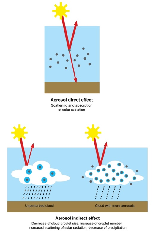
The primary climatic effect of aerosols is their influence on radiative forcing (direct effect). Sulfuric acid aerosols, due to their high reflectivity, scatter incoming solar radiation which induces a cooling effect. In contrast, black carbon and dust aerosols absorb radiation, contributing to warming. On a global scale, the combined radiative forcing of aerosols is a net cooling effect with sulfate aerosols as the principal contributor. This effectively offsets approximately one-third of the greenhouse effect induced by other anthropogenic emissions (Li et al. 2022). However, regional variations in aerosol composition lead to differing net climatic effects, with some areas experiencing a dominance of absorbing aerosols, leading to localized warming.
Aerosol-Cloud Interactions
Aerosols influence cloud microphysics and precipitation patterns in a significant way (indirect effect). Sulfate aerosols, when suspended in the atmosphere, act as cloud condensation nuclei, facilitating cloud formation but reducing the likelihood of precipitation by forming smaller, more numerous cloud droplets (Jin et al. 2023). This phenomenon, known as cloud brightening, increases cloud albedo and contributes to an overall cooling effect. It also effectively hinders the ability of cloud droplets to form, suppressing overall precipitation.
Health and Social Impacts
Although not the direct purpose of this paper, it is worth briefly mentioning the health and social impacts of anthropogenic aerosols. Exposure to fine particulate matter, particularly black carbon and sulfates, is associated with respiratory diseases, cardiovascular conditions, and premature mortality. According to the WHO, air pollution was responsible for approximately 4.2 million premature deaths worldwide in 2016 (World Health Organization, 2018), with an estimated economic cost of USD 5.7 trillion, equivalent to 4.8% of global GDP (The World Bank, 2019). Additionally, the distribution of anthropogenic aerosols is disproportionately affecting lower-income and developing regions, exacerbating environmental injustice. Many communities in these regions lack access to clean energy alternatives and are heavily reliant on biomass and fossil fuel combustion, further intensifying aerosol emissions and their adverse effects.
Collectively, these global impacts impress the urgent need to identify and refine methods of monitoring atmospheric aerosols, their sources, and their impacts. These efforts began with specific emphasis on environmental impact in the 1970’s (McMurry, 2000) and have been ongoing ever since. These measurement methods can be organized into two general categories, Traditional (Surface or Airborne) Methods, and Remote Sensing Methods. These will be discussed in the following sections.
Traditional Methods of Aerosol Measurement
Traditional methods of aerosol measurement are divided into two general approaches: Chemical Sampling and Radiometric Analysis. These approaches are often used in tandem to calibrate and evaluate each other’s measurements.
Sampling
Aerosol sampling is an in-situ measurement process where a sample of the atmosphere is collected for detailed analysis. This method is beneficial because researchers can perform much more detailed analysis on the aerosol chemical makeup than is possible in the open air (Ahmed et al., 2009). Sampling does have significant limitations since the equipment required is both expensive and difficult to move. Sampling, therefore, while very accurate does not offer an effective means to monitor global aerosol levels.
With aerosol sampling, researchers often hope to identify the concentration and characteristics of a certain aerosol. A sample of the atmosphere at a specific time, place and altitude is then retrieved. That sample is then passed through a series of filters designed to remove unwanted particulates (Lenoble et al., 2013). The desired aerosol is then isolated and measured through a variety of means (Bond et al., 2013).
Radiometric Analysis
While Sampling offers a very precise in-situ method of measuring aerosol content, researchers have also developed means to monitor aerosols from a distance using their optical and radiometric properties. These methods can be divided into active and passive modes of observation. Once radiometric data is received, it must go through a variety of algorithms to assess its characteristics against known atmospheric and aerosol characteristics. This analysis often involves several assumptions based on scientists’ a priori knowledge (Clarisse et al., 2013).
Passive forms of observation are certainly the most abundant. With this method, sensors analyze incident solar radiation at the bottom of the atmosphere and compare its measurements against known readings in a clear atmosphere. This analysis at multiple wavelengths is then compared with known aerosol characteristics including refractive indices, and absorption bands. With a series of accurate assumptions, researchers can estimate aerosol content and altitude.
Active forms of observation allow researchers to match atmospheric scattering qualities with known aerosol qualities to measure atmospheric makeup. Light Detecting and Ranging (LIDAR) is the most common form of active measurement. Here, light is sent at a specific wavelength(s) and with a specific polarization through the atmosphere. A collocated detector then measures backscattering, and polarization shifts (Comeron et al., 2017). This data is compared with known aerosol values to make measurements. In recent studies, LIDAR has been efficiently used to detect quantity and altitude of soot emissions from known pollution zones (Elbakary et al. 2019). It is also important to note that active, non-LIDAR methods exist where lasers are sent through an atmospheric sampling to make similar measurements using forward scattering instead of back scattering (Bond et al., 2013).
Examples of Traditional Measurements
Below are several examples of traditional aerosol detection methods and instruments. This list is not comprehensive, but captures each of the primary categories discussed above:
GMAP
The EPA’s Geospatial Measurement of Air Pollution (GMAP) vehicle demonstrates state of the art sampling technologies onboard a ground-mobile platform. GMAP has been shown to provide accurate measurements of both Sulfates ( GMAP Facts Sheet ) and Black Carbon (Steffens et al., 2017). GMAP is used by the EPA to investigate specific chemical pollutants (including anthropogenic aerosols) around industrial sites. By equipping a vehicle with multiple sampling devices, researchers can monitor and track aerosol pollutants in target areas.
AERONET
The Aerosol Robotic Network (AERONET) is a global system that measures aerosol optical depth (AOD) by comparing observed solar radiation with expected values under clear-sky conditions (Wei et al. 2019). This passive observing network, comprising over 500 sites worldwide, has provided more than 25 years of continuous ground-based aerosol data. Each AERONET station measures local aerosol concentrations using sun photometers and solar-powered radiometers. These instruments collect data at eight distinct wavelengths, which are subsequently processed through inversion algorithms. Processed AERONET data is used globally as the benchmark for AOD and certain measurements of different aerosol types.
LIDAR
As discussed, LIDAR offers a helpful alternative to passive optical sensing by leveraging specific wavelengths and polarizations to determine aerosol qualities. Many studies have been conducted of AOD and other aerosol qualities using ground and airborne based LIDARs. In one such study, Granados-Munoz et al. demonstrate the usefulness of CAS-POL, an airborne LIDAR, along with other in-situ instruments to measure concentrations of dust aerosols propagated from the Sahara over Spain (Granados-Munoz et al., 2016).
These traditional methods provide essential insights into atmospheric aerosols, aiding in the understanding of their composition, distribution, and radiative effects. However, traditional non-satellite methods are not continuous, nor are they global making them a useful but imperfect method of global aerosol monitoring. For this reason, an abundance of research and development has been invested into the Remote Sensing of anthropogenic aerosols.
Remote Sensing of Anthropogenic Aerosols
Among the many classifications of aerosol remote sensing, the most differentiated are between the visible and infrared spectrums. The visible spectrum offers extensive datasets and simpler inversion algorithms to make broad assessments of the overall atmospheric Aerosol Optical Depth (AOD). These wavelengths, though, offer fewer opportunities to delineate between different types of aerosols. IR bands, on the other hand, offer much better measurements of individual aerosol concentrations. Their inversion algorithms, though, require large computational power. In this section, we will discuss the different methods of aerosol observation within these categories.
The Infrared (IR) Spectrum
Anthropogenic aerosols exhibit strong refractive properties, which can be effectively leveraged for remote sensing in the IR spectrum. This spectrum generally spans between 3-15μm and uses instruments designed to measure thermal qualities of the earth’s surface (Lenoble et al., 2013). In this spectrum, satellite instruments rely on consistent thermal emissions from the earth’s surface and atmosphere to measure radiative changes triggered by aerosols. One unique distinction that this provides from the visible spectrum is that IR readings can be taken in the absence of sunlight.
IR readings are influenced by numerous parameters, including temperature, altitude, cloud cover, and the presence of various other aerosols, necessitating measurements across multiple points along the IR spectrum. For this reason, it has been historically difficult to observe aerosols in the IR, however, with the advent of high-resolution sounders, we are able to observe aerosol properties within small spectral ranges (Clarisse et al. 2010). All these factors represent an opportunity for future research.
The IR Radiative Transfer Equation (RTE)
Researchers use the IR RTE to model how IR radiation travels through the atmosphere. This model, can be paired with our satellite readings and several precise assumptions to measure anthropogenic aerosols.
The most general form of the IR RTE tells us that there are three sources of IR radiation that will be observed from satellites:
-
Black Body radiation emitted from the surface of the earth and transmitted through the atmosphere.
-
Black Body radiation emitted downward from the atmosphere and reflected back upward by the surface.
-
Black Body radiation emitted upward from the atmosphere
The collection of this radiation is simply represented as:
Where is the radiance of the surface, is the downwelling sky radiance, is the atmospheric path radiance, is the emissivity of the surface, is the reflectivity of the surface, and is the transmissive properties of the atmosphere (Chapman, Gasparovic, 2022).
Observable Properties of Aerosols in the IR Spectrum
The RTE equation is extremely helpful to evaluate basic surface and atmospheric qualities under ideal conditions. However, aerosol size, composition, shape, temperature and chemical makeup all have strong influence over ,, making calculations more complex. But the changes to these values are also allows researchers to measure aerosol qualities (Lenoble et al., 2013; Clarisse et al., 2013). As demonstrated in Figure 2 and Figure 3, the principle characteristic used to detect aerosols in the IR band is their tendency to absorb radiation at a given wavelength (Clarisse et al., 2013). As an example of this process, one may take measurements at two wavelengths, one known to be affected by an aerosols absorption (sample wavelength) and one known to be unaffected (control wavelength). Comparison of these two readings yields aerosol observations.
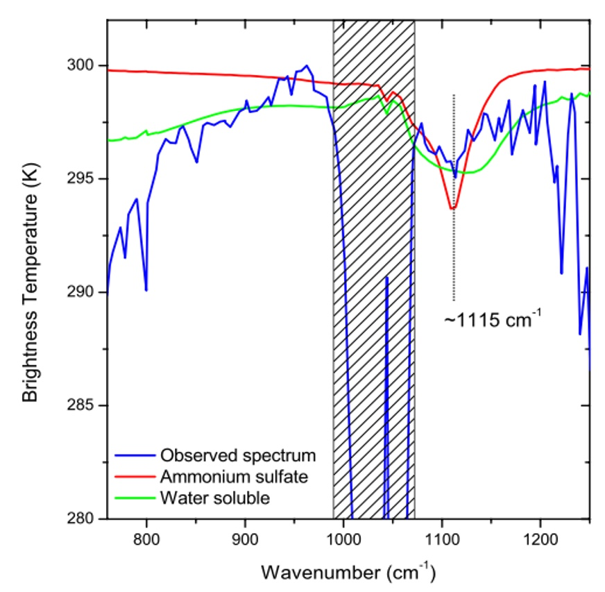
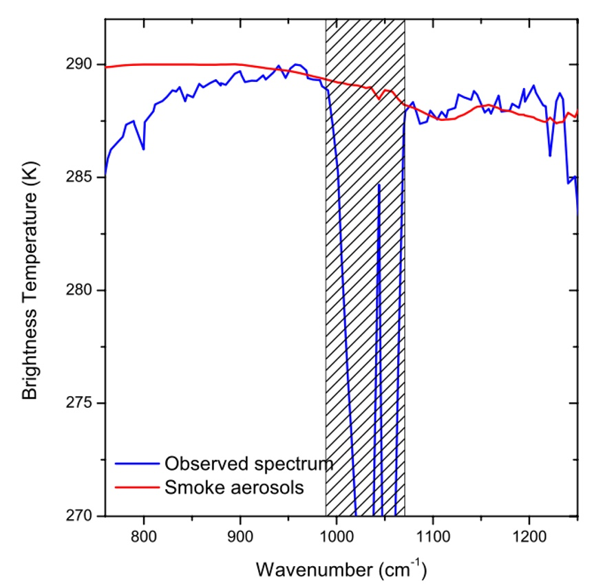
In addition, aerosols behave differently at these absorption bands based on their altitude and temperature (Clarisse et al., 2013). Researchers make use of complex models to then determine these qualities through atmospheric sounding (Chapman, Gasparovic, 2022).
The inherent challenge is that aerosols are often co-mingled with absorption bands at similar wavelengths. This requires more complex analysis with many parameters which will be discussed
Inversion Algorithms for the IR RTE
Brightness Temperature Difference (BTD) - BTD is the simplest method for aerosol detection, requiring only two spectral channels tailored to the aerosol of interest (Clarisse et al., 2013). One channel provides a baseline brightness measurement, while the second is selected based on its sensitivity to the target aerosol. The difference in measurements between these channels is used to estimate aerosol concentration. Although this method is computationally simple, it is highly sensitive to noise from unmodeled atmospheric components. Therefore, this method is often used as a basic reference, or when the overall atmospheric composition is well known.
Spectral Fitting - Spectral fitting is a mathematically rigorous approach that incorporates a forward model with numerous parameters, including target molecules, surface temperature, interfering gases, aerosol radii, altitude, and viewing angle (Clarisse et al., 2013). The model initially includes multiple assumed unknowns and incorporates known values where possible. A least-squares error minimization process is then applied to adjust variable weights (representing aerosol content) to match observed measurements. This approach is exhaustive comparing the maximum number of available wavelengths against the maximum number of potential atmospheric inclusions.
Principal Component Analysis (PCA) - PCA is a computationally efficient alternative to spectral fitting, based on the assumption that the number of spectral measurements exceeds what is necessary to evaluate primary substances of interest (Clarisse et al., 2013). This method selects only a subset of spectra corresponding to the most significant contributing materials, including the target aerosols. PCA reduces instrumental noise from unnecessary spectra, improving measurement precision. However, it has the drawback of not utilizing the full dataset, making it sensitive to environmental anomalies that may distort calculations.
Look-Up Tables (LUTs) - LUTs offer an alternative to computationally intensive spectral fitting (Clarisse et al., 2013). This method involves precomputed tables of known variables and associated hyperspectral measurements. Observed measurements are compared against the LUT, and the best match is identified by minimizing the spectral distance between observed and reference data using mean square error (MSE) analysis. While LUTs function similarly to spectral fitting, they are computationally less exhaustive.
Additional Considerations in IR Data Interpretation
While these methods provide valuable instantaneous measurements, additional insights can be obtained through short-term time series analysis (e.g., daily observations over 2–3 weeks). Notably, many anthropogenic aerosols have closely spaced absorption bands, making differentiation challenging. For instance, sulfuric acid (H₂SO₄) exhibits absorption at 9.09 microns, while sulfur dioxide (SO₂) absorbs at 8.68 microns. Since these substances are frequently co-located, a combination of measurement techniques is required to distinguish between them accurately.
Satellite-Based Observations of the IR Spectrum
There are several satellites which are actively measuring IR spectra in a way to make meaningful aerosol observations:
AIRS (Aqua): The Atmospheric Infrared Sounder (AIRS) is a high-resolution IR sounder aboard the EOS-Aqua polar orbiting satellite. AIRS consists of 2,378 hyperspectral IR detectors, enabling precise atmospheric profiling at varying altitudes. This device was designed to make atmospheric temperature, hydration and weather prediction observations. However, its hyperspectral grating has proven exceedingly useful for making observations about anthropogenic aerosols at varying altitudes (Prata et al., 2007).
IASI (MetOp): The Infrared Atmospheric Sounding Interferometer (IASI) is one of ESA’s leading infrared sounding instruments. The IASI flies aboard the MetOp satellite, a polar orbiting satellite with an array of weather forecasting instruments. IASI is a popular for aerosol sensing for its large number of IR observation bands. In fact, the number of bands far exceeds the number of channels required to make meaningful measurements. This makes IASI data optimal for Principle Component Analysis, limiting the number of channels used to minimize instrument noise (Clarisse et al., 2013).
Passive Remote Sensing in the Visible Spectrum
While the IR spectrum offers opportunities to distinguish between individual aerosols, the visible spectrum is typically restricted to providing information about aerosol concentrations collectively. While this may be limiting in some applications, it is perfectly sufficient for many others. The visible spectrum also often requires fewer assumptions and simpler calculations making it a meaningful method of aerosol remote sensing.
The Visible Radiative Transfer Equation
Passive observation of atmospheric aerosols in the visible spectrum relies on sunlight that is reflected off the Earth's surface and scattered through the atmosphere. This can be modeled with the same RTE as IR:
However, as opposed to IR, in the visible spectrum, provides much less radiation, while , provides the vast majority of measured radiation due to downwelling solar radiation.
Like the IR spectrum, measurements at multiple wavelengths are compared to determine aerosol attenuation at different altitudes. This approach focuses on determining which when compared to baseline, represents the level of aerosol loading in the atmosphere, or, Aerosol Optical Depth (AOD) (Wei et al. 2019). AOD is often determined at multiple altitudes via sounders (Lenoble et al., 2013) giving researchers accurate measurements of 1) current aerosol concentrations, 2) expected aerosol lifespan, 3) forecast of aerosol transportation (McGill et al., 2020).
Because the earth’s surface varies so greatly by location, parameters required to establish control measurements also vary rapidly. Models are therefore dependent known qualities like ocean reflectivity and bidirectional reflectance distribution function (BRDF) to establish these control readings (Kahn, 2013).
One final consideration in the visible RTE is a significantly low signal-to-noise ratio. There are many substances in the atmosphere and much fewer visible wavelengths to differentiate them. Inversion algorithms must account for this and adjust their measurement wavelength spatiotemporally (Kahn, 2013).
Aerosol Properties in the Visible Spectrum
The visible spectrum can measure many aerosol qualities: Particle size influence what wavelengths it impacts (Lenoble et al., 2013); particle shape influences how radiation changes when it impacts the substance (Clarisse et al., 2013); and particle chemical composition can change both the polarization and refraction/absorption of a substance (Ahmed et al., 2009). Although these qualities make calculation complex, they also offer an abundance of observation opportunity for remote sensing.
The overall impact that Aerosols emit on visible radiation is seen in two radiative characteristics: 1) Scattering, 2) Polarization Shifts (Lenoble et al., 2013). In general, for passive remote sensing, researchers rely heavily on aerosol forward scattering properties while in active remote sensing, they can leverage polarization and backward scattering. These qualities are interpreted through location dependent inversion algorithms which will be discussed in the next section.
Interpretation of Aerosol Data in the Visible Spectrum
The most significant challenge faced when using visible data is the inconsistency in surface color and radiance over varying locations (Kahn, 2013). For this reason, inversion algorithms have been developed to handle data interpretation over different surface types. A selection of these is listed in Table 1 followed by a detailed summary of the most popular algorithms.
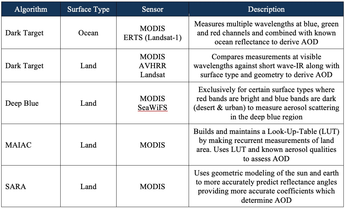
Dark Target (DT) Algorithm: DT is one of the most successful algorithms for measuring AOD because it leverages the dependability of ocean reflectance. DT assumes a distribution of fine and course shaped aerosols based on a single weight variable. Irradiance is then captured at 0.87μm which has minimal reflectance at the water’s surface. The irradiance is compared against a LUT to determine AOD (Wei et al., 2019).
The DT algorithm has also been adjusted for use over vegetated surfaces with certain restrictions. DT uses measurements at the near-IR 2.12 μm channel which is nearly transparent through the atmosphere to determine surface reflectance. The algorithm uses a LUT to model the likely aerosol makeup of the region based on season and location. Irradiance values at 0.47 μm and 0.66 μm are then compared against the measured surface reflectance to determine AOD (Wei et al., 2019).
Deep Blue (DB) Algorithm: DB is particularly effective in regions where the surface is reflective in the red and near-infrared bands but dark in the blue spectrum (e.g. deserts and urban areas) (Wei et al., 2019). The algorithm references a surface reflectance LUT which gives average global surface reflectance to a 0.1° lon/lat resolution. DB makes measurements at ~0.41 μm where surface irradiance is minimized. Aerosols exhibit relatively high radiance in this range (Kahn, 2013) providing ample opportunity to measure AOD. DB is extremely sensitive to clouds so pixels containing clouds are excluded.
Multi-Angle Implementation of Atmospheric Correction (MAIAC): MAIAC uses multi-day data collected over a single region—five days at the poles and sixteen days at the equator. It employs composite readings at 2.1 microns to determine the bidirectional reflectance distribution function (BRDF), which is then used to construct a lookup table. By incorporating BRDF for a given area and measurements at other wavelengths, MAIAC effectively determines AOD (Hu et al., 2013).
Active Remote Sensing in the Visible Spectrum (LIDAR)
In contrast to passive sensing, LIDAR is an active remote sensing technique that measures atmospheric makeup by firing laser signals at specific wavelengths and polarizations to detect backscattering (Prata et al., 2017). Spaceborne LIDAR systems are more limited than sub-atmospheric LIDAR systems because their large ground swath creates low resolution. Additionally, spaceborne systems are limited by power output, placing restrictions on the strength of the LIDAR systems. Because anthropogenic aerosols are typically dispersed in lower quantities at lower altitudes than natural aerosols, LIDAR systems tend to be leveraged more for the latter.
Despite these limitations, spaceborne LIDAR systems have been shown to provide useful information about atmospheric composition at large scales. Despite the low resolution, researchers can leverage precise wavelengths and polarizations that LIDAR affords to make accurate AOD and altitude measurements from space (McGill et al. 2020). Figure 4 provides an example of the potential power that LIDAR provides when sampling large areas.
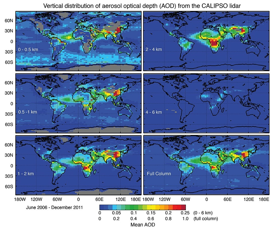
Researchers have recently explored the application of machine learning (ML) techniques to compensate for the weaknesses of spaceborne LIDAR systems (Yorks et al., 2021). ML algorithms have been successfully applied to the Cloud-Aerosol Transport System (CATS) LIDAR data, demonstrating improvements in noise reduction and background light suppression, which enhance overall LIDAR detection capabilities.
Two state-of-the-art LIDAR systems currently used to track aerosol propagation are:
China’s ACDL (2024): The Atmospheric Carbon Dioxide Detection LIDAR (ACDL) is the first spaceborne High-Spectral-Resolution LIDAR system of its kind, launched in 2024 (Liu et al., 2024). This system is equipped with a specialized detector which can delineate between Mie (or particulate) backscattering and Rayleigh (gaseous) backscattering. This first-of-its-kind sensor was very recently deployed, but has proven the capacity for LIDARs to make meaningful measurements of anthropogenic aerosols. It is hoped that this advancement will lay a path for future research.
CATS & CALIOP: Both CATS and CALIOP are spaceborne LIDAR systems. CATS operates aboard the International Space Station (ISS), while CALIOP is aboard the CALIPSO satellite. CALIOP operates at 532nm and 1064nm wavelengths providing a helpful combination of visible and near-IR readings. These instruments are not as advanced as the ACDL, but they do provide valuable aerosol profile data essential for climate and air quality research (Prata et al., 2017). While these systems have demonstrated applicability of LIDAR (Vuolo et al., 2009), their moderate resolution has limited their applicability to large aerosol measurements limiting their applicability for anthropogenic aerosols emitted in smaller quantities. To compensate for this challenge, multiple retrieval algorithms like SIBYL have been developed to decipher readings from weak backscattered signals (Wei et al., 2019).
Conclusion
The observation of anthropogenic aerosols from space has proven to be an invaluable tool for understanding their impact on climate, air quality, and human health. Traditional measurement methods, while highly precise, remain limited in their spatiotemporal coverage. Remote sensing techniques, both in the visible and infrared spectra, have allowed researchers to monitor aerosol composition, concentration, and transport on a global scale. By leveraging passive and active sensing methods—such as multi-wavelength radiometric analysis and LIDAR—scientists have been able to refine our understanding of aerosol properties, their interactions with clouds, and their role in radiative forcing. Despite advances in aerosol detection, challenges remain in distinguishing between aerosol types and quantifying their exact climatic effects, particularly for anthropogenic sources that require fine-scale monitoring.
Future advancements in remote sensing technology will further enhance our ability to track aerosols with greater accuracy and resolution. Emerging satellite instruments, such as China’s ACDL and high-resolution IR sounders like IASI, represent a promising direction for aerosol observation, enabling differentiation between aerosol species and improving climate models. As anthropogenic aerosol emissions continue to shape regional weather patterns and global climate trends, the ability to monitor these particles from space will remain critical for informed policy decisions, mitigation strategies, and environmental justice efforts worldwide. Continued investment in spaceborne aerosol observation will ensure that scientists and policymakers have the necessary data to address the evolving challenges posed by anthropogenic aerosols.
Citations:
Ahmed, T., Dutkiewicz, V., et al. (2009). Measurement of black carbon (BC) by an optical method and a thermal-optical method: Intercomparison for four sites.
Bollasina, M., Ming, Y., Ramaswamy, V., Schwarzkopf, D., Naik, V., (2014). Contribution of local and remote anthropogenic aerosols to the twentieth century weakening of the South Asian Monsoon.
Bond, T., Doherty, D., et al. (2013). Bounding the role of black carbon in the climate system: A scientific assessment.
Boucher, O. (2015). Atmospheric Aerosols. In: Atmospheric Aerosols. Springer, Dordrecht.
Carn, S., Fioletov, V., McLinden, C. et al. (2017). A decade of global volcanic SO2 emissions measured from space. Sci Rep 7, 44095.
Chapman, R., & Gasparovic, R. (2022). Remote Sensing Physics: An Introduction to Observing Earth from Space. John Wiley & Sons.
Clarisse, L., Coheur, P.F., et al. (2013). A unified approach to infrared aerosol remote sensing and type specification.
Clarisse, L., Hurtmans, D., Prata, A. J., Karagulian, F., Clerbaux, C., Mazie`re, M. D., and Coheur, P.-F. (2010). Retrieving radius, concentration, optical depth, and mass of different types of aerosols from high-resolution infrared nadir spectra.
Comeron, A., Munoz-Porcar, C., et al., (2017). Current Research in Lidar Technology Used for the Remote Sensing of Atmospheric Aerosols.
Cowan, T., Cai, W., (2011). The impact of Asian and non-Asian anthropogenic aerosols on 20th century Asian summer monsoon.
Elbakary, M., Abdelghaffar, H., et al. (2020). Aerosol tracking using lidar-based atmospheric profiling and Bayesian estimation
Ganguly, D., Rasch, P., Wang, H., Yoon, J., (2012) Climate response of the South Asian monsoon system to anthropogenic aerosols.
Granados-Muñoz, M., Bravo-Aranda, J., et al., (2016). A comparative study of aerosol microphysical properties retrieved from ground-based remote sensing and aircraft in situ measurements during a Saharan dust event.
Hu, X., Waller, K., Lyapustin, A., et al., (2013). Estimating ground-level PM2.5 concentrations in Southeastern United States using MAIAC AOD retrievals and a two-stage model
Jin, J., Henzing, B., Segers, A., (2023). How aerosol size matters in aerosol optical depth (AOD) assimilation and the optimization using the Angstrom exponent.
Khan, R., (2013). Satellite Remote Sensing: Aerosol Measurements.
Lenoble, J., Remer, L., & Tanre, D. (2013). Aerosol remote sensing. Springer.
Li, J., Carlson, B.E., Yung, Y.L. et al. (2022). Scattering and absorbing aerosols in the climate system. Nat Rev Earth Environ 3, 363–379.
Liu, Q., Huang, Z., et al., (2024). Validation of initial observation from the first spaceborne high-spectral resolution lidar with a ground based network.
McGill, M., Swap, R., Yorks, J., Selmer, P., Piketh, S., (2020). Observation and quantification of aerosol outflow from southern Africa using Spaceborne lidar.
McMurry, P., (2020). A review of atmospheric aerosol measurements.
Mishra, V., Dangar, S., Tiwari, V., Lall, U., Wada, Y., (2024). Summer Monsoon Drying Accelerates India’s Groundwater Depletion Under Climate Change.
Myhre, G., Myhre, C., Samset, B., Storelvmo, T., (2013). Aerosols and their Relation to Global Climate and Climate Sensitivity.
Prata, A., Bernardo, C., (2007). Retrieval of Volcanic SO2 column abundance from Atmospheric Infrared Sounder data.
Steffens, J., Kimbrough, S., et al. (2017). Near-port air quality assessment utilizing a mobile measurement approach.
The World Bank: The hidden wealth of Nations: The economics of groundwater in times of climat change. (2023). https://documents1.worldbank.org/curated/en/099257006142358468/pdf/IDU0fb2550de013100434708d920a3e3bec6afb1.pdf
The World Bank: Pollution, Tech. rep., https://www.worldbank.org/en/topic/pollution#3, last access: 18 December 2019.
Vuolo, M., Chepfer, H., Menut, L., Cesana, G., (2009). Comparison of mineral dust layers vertical structures modeled with CHIMERE-DUST and onserved with the CALIOP lidar.
Wei, X., Chang, N. B., Bai, K., & Gao, W. (2019). Satellite remote sensing of aerosol optical depth: advances, challenges, and perspectives. Critical Reviews in Environmental Science and Technology, 50(16), 1640–1725.
World Health Organization: Ambient (outdoor) air pollution, Tech. rep., https://www.who.int/news-room/fact-sheets/detail/ambient-(outdoor)-air-quality-and-health (last access: 18 December 2019), 2018.
Yorks, J. E., Selmer, P. A., Kupchock, A., Nowottnick, E. P., Christian, K. E., Rusinek, D., Dacic, N., & McGill, M. J. (2021). Aerosol and Cloud Detection Using Machine Learning Algorithms and Space-Based Lidar Data. Atmosphere, 12(5), 606.